 SEGLY
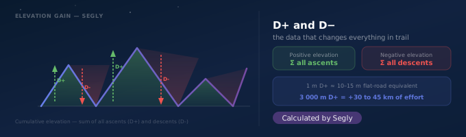
You're looking at a race profile: 42 km, and then that number that changes everything — 2,400 m D+. Two runners covering the same distance can have radically different races depending on the elevation. In trail and ultra-trail running, distance only tells part of the story: it's the elevation gain that determines race time, muscular fatigue and the strategy to adopt.
What is positive elevation gain (D+)?
Positive elevation gain, written D+, is the sum of all the metres climbed over a course. Concretely, if a trail climbs 100 m, descends 30 m, then climbs back 50 m, the cumulative D+ is 150 m (100 + 50), regardless of the starting or finishing altitude. It is a cumulative measurement, not a simple difference between the lowest and highest point.
What is negative elevation gain (D-)?
Negative elevation gain, written D-, is the exact mirror of D+: the sum of all the metres descended over the course. On a loop that returns to its starting point, D+ and D- are equal. On a linear course (point A to point B at a different altitude), they generally differ.
D- is often underestimated by runners, even though a long, technical descent generates muscular stress (eccentric loading) at least as significant as the climb — it is one of the primary causes of quadriceps pain and falls in the final stages of a race.
Why elevation matters more than distance in trail running
Two 50 km courses can have race times that differ by a factor of two depending on their profile. Trail running time estimation methods generally convert each metre of D+ into a flat-distance equivalent (often between 10 and 15 times the elevation gain, depending on the gradient and the runner's level). A course with 3,000 m D+ can thus represent, in terms of effort, the equivalent of 30 to 45 additional kilometres compared to a flat course of the same length.
This is why comparing two races solely on their distance is misleading: a very hilly 30 km can be more demanding than a rolling 60 km.
How to calculate the elevation gain of a course
Three main sources, sometimes with very different results:
| Source | Reliability | Note |
|---|---|---|
| D+ announced by the race organiser | Good reference | Calculated from the official course with a smoothed elevation model |
| D+ measured by GPS watch | Variable | Depends on the barometric sensor — can vary by several hundred metres |
| D+ calculated from a GPX file | The most accurate | Requires an appropriate smoothing algorithm to avoid overestimation |
The GPX method with smoothing, applied to a reliable file, generally gives the estimate closest to the reality of the terrain.
Elevation and race strategy: what it changes in practice
Knowing the D+ and D- of a course, segment by segment, allows you to adjust three essential things:
- Pace: slow down ahead of a long climb rather than hitting it at full fatigue.
- Nutrition: prolonged climbs increase energy expenditure and may justify increased carbohydrate intake before entering them.
- Mental anticipation: knowing that a technical 800 m D- descent arrives at km 35 allows you to stay focused to negotiate it rather than simply endure it.
D+ and D- on each segment, not as a global average
A global D+ of 2,400 m over 42 km tells you little about how that elevation is distributed. Two races with exactly the same total D+ can have radically different profiles: one concentrates all the climbing over 10 km, the other spreads it across a succession of small hills. The segment-by-segment profile is what really matters for building a strategy.
This is why Segly automatically calculates the D+ and D- of any course, segment by segment, from a simple GPX file import — and directly derives the target pace, nutrition needs and equipment strategy for each portion of the race.
Key takeaways
- D+ is the cumulative sum of all metres climbed — not the difference between the lowest and highest point.
- D- is often underestimated: prolonged descents damage the quadriceps and cause falls in the final stages of a race.
- 1 m D+ ≈ 10 to 15 m flat equivalent: a hilly 30 km can be harder than a rolling 60 km.
- The most reliable method to calculate D+ is a GPX file with an appropriate smoothing algorithm.
- It is the D+ and D- segment by segment that allow you to build a real race strategy.
See also
Segly automatically calculates the D+ and D- of each segment of your course. Import your GPX file on segly.vo2run.app to get a race plan with the recommended pace, nutrition and equipment for each portion.