 SEGLY
SEGLY
Your trail running time is off. And it's not your fault.
You did the math, you prepared, you studied the course profile. And yet, during the race, everything falls apart at the first pass. Not because you’re out of shape. Because you made the mistake everyone makes: you treated every kilometer the same.
A kilometer on flat ground and a kilometer at 2,500 meters in elevation aren’t the same effort. A gentle descent and a steep scree slope aren’t the same pace. Your race plan needs to account for this. That’s exactly why we designed the Progression Factor in Segly.
Why Not All Kilometers Are Equal
In trail running and ultra-trail running, the classic mistake is to think in terms of average pace—“I’ll run at 7 min/km”—and apply that number to the entire course. It works on the road. It doesn’t work in the mountains.
The terrain dictates its own rules. On a steep climb, you might be running at 15 min/km. On a fast, rolling descent, you’ll drop below 5 min/km. If you plan your UTMB, Grand Raid, or even a local trail with varied terrain using a single pace, you’re going to fail: too optimistic on the climbs, too conservative on the descents, and completely drained in the final third.
What you need is a segment-by-segment analysis that takes into account what each section will actually cost you. That’s where Segly’s algorithm comes in.
What the algorithm calculates: elevation gain (D+), gradient, and altitude
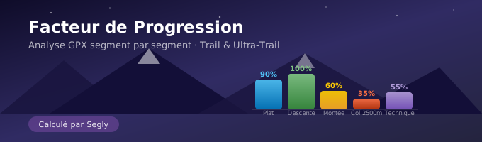
In Segly, each segment of your GPX file is assigned a Progression Factor—a value between 0% and 100%.
- 100% → gentle descent, ideal conditions. This is your speed limit.
- ~90% → flat terrain. Slightly lower due to resistance from exertion.
- Below that, every terrain challenge lowers the number.
The algorithm takes three criteria into account:
Elevation gain (D+)
The steeper the climb, the more your factor drops. The energy expended on climbing mechanically slows your progress.
The slope—in both directions
The slope affects you both ways. A gentle descent boosts your factor. A descent that’s too steep causes it to drop—you brake, you lose energy, you take risks. Just because you’re going downhill doesn’t mean you’re going fast.
Altitude
Below 1,500 m, there’s no measurable impact. Above that, the air gets thinner, oxygen levels drop, and so does your performance. The algorithm factors this in directly. On a high-altitude route—like skyrunning or alpine crossings—this radically changes your times.
Result: for each segment of your GPX, Segly gives you a precise number, not a rough estimate.
What the algorithm doesn’t know—and why that’s by design
The algorithm is powerful. But it has blind spots, and we prefer to be honest about that.
Technical terrain. Scree, mud, sand. Same GPX profile, same elevation gain—you move half as fast as you would on a well-marked trail. This information isn’t included in a GPX file. GPS doesn’t detect ground texture.
The weather. Headwinds, driving rain, 35 °C heat, thunderstorms at high altitudes. These conditions can drastically slow you down. There’s no weather data in a GPX file.
Faced with these limitations, we made a clear choice: put the power in the user’s hands. You know your terrain better than any algorithm. In Segly, you can manually adjust the Progression Factor for each segment. The app recalculates instantly.
Objective data from the algorithm + the athlete’s on-the-ground experience = a reliable time estimate. That’s the Segly philosophy.
How to Use Segly in Practice
- Import your GPX file to segly.vo2run.app. The app automatically splits your route into logical segments.
- Check the Progression Factor for each segment: elevation gain, gradient, altitude—everything is already factored in.
- Identify the segments you’re familiar with. Scree, muddy sections, fast-paced stretches… You know what the GPX file doesn’t tell you.
- Adjust the slider on the relevant segments. Segly recalculates in real time.
- Get your realistic race time, segment by segment. Not a rough guess—a usable race plan.
It’s the same process that elite runners have been doing manually for years, now automated and accessible to everyone.
Your next trail run deserves a realistic time
Trail training preparation is all too often an optimistic estimate multiplied by the number of kilometers. That leads to times that fall apart halfway through the race, missed aid stations, and a painful finish.
The Progression Factor is the tool that was missing between “I’m aiming for X hours” and the reality on the trail. It doesn’t promise perfection—there are things no algorithm can predict. But it gives you a solid foundation, segment by segment, which you can refine with the insights only you possess.
Analyze your next route right now at segly.vo2run.app.